François Valentijn (AKA Valentyn), Oud en Nieuw Oost-Indien (Dordrecht and Amsterdam, Johannes van Braam and Gerard onder de Linden, 1724 - 6), volume 5.
Norwich # 214; not in Tooley. The map is analysed in some detail by Petrus Serton
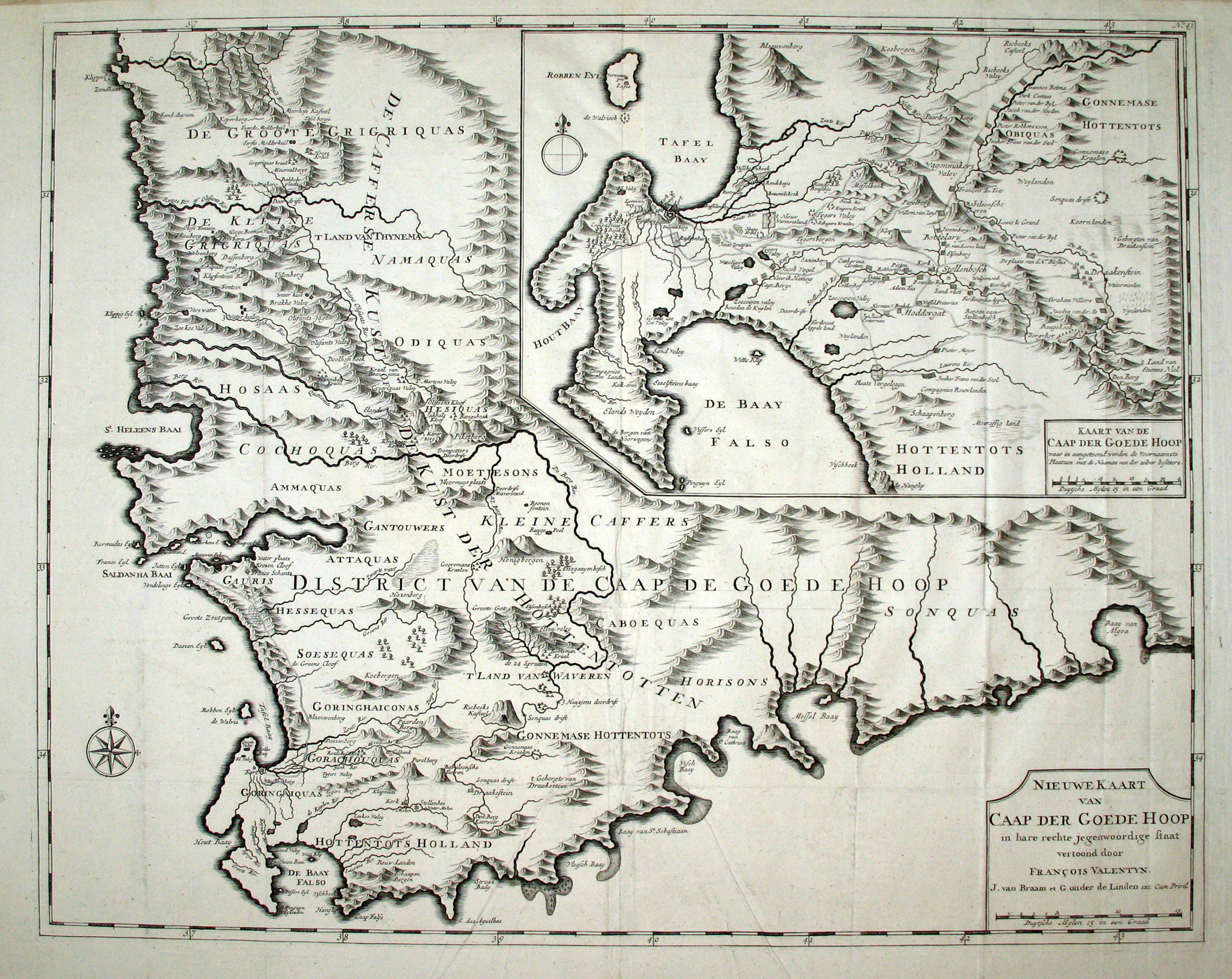
This eclectic map was surprisingly influential and is the first printed map to show part of Simon van der Stel's 1685 successful journey to the north, to the Copper Mountains (the party's exploratory diggings can be seen near today's town of Springbok).
François Valentijn (1666-1727) was a Calvinist Minister and an historian of the Vereenigde Oost-Indische Compagnie (V.O.C.), the United Dutch East Indian Company. His book, Oud en Nieuw Oost-Indien (Old and New East-India), described the VOC settlements and and trade in the Far East, Ceylon, Mauritius and Cape of Good Hope. This massive work of eight folio volumes comprises approximately 5 000 double column pages and 1 000 illustrations. Beschryvinge van de Kaap der Goede Hoop (Description of the Cape of Good Hope) comprises four chapters in Volume 5 of the book; and it includes this map.
Valentijn knew the south-western corner of the Cape Colony well. In 1685, 1695, 1705 and 1714 he visited the expanding Dutch colony en route to and from the Far East, the total duration of his residence being a little more than six months. While the map is attributed to Valentijn, the cartographer and engraver were probably associated with the VOC; nevertheless, Valentijn almost certainly contributed to the content of the map.
The main map, Nieuwe Kaart van Caap der Goede Hoop, depicts almost the entire colony known at that time, while the inset, Kaart van de Caap der Goede Hoop (31.2cm x 21.9cm), shows the second eastward expansion of the colony, i.e. beyond the Liesbeek River, copied from the Loots map (map #4). While Valentijn had not travelled to the north, he was the first to publish new cartographic information on a narrow strip of the interior of the west coast, along the old 'northern highway' which was used initially to search for the fabled riches of Monomotapa. Valentijn obtained information on the northern route from the journals of the expeditions led by Simon van der Stel (in 1685 - 1686) and Johannes Starrenburg (in 1705). Despite numerous inaccuracies and anachronisms, Valentijn's map had a surprisingly significant impact on maps of the region; for example, it was copied for inclusion in the posthumous, Dutch edition of Peter Kolbe's book.
