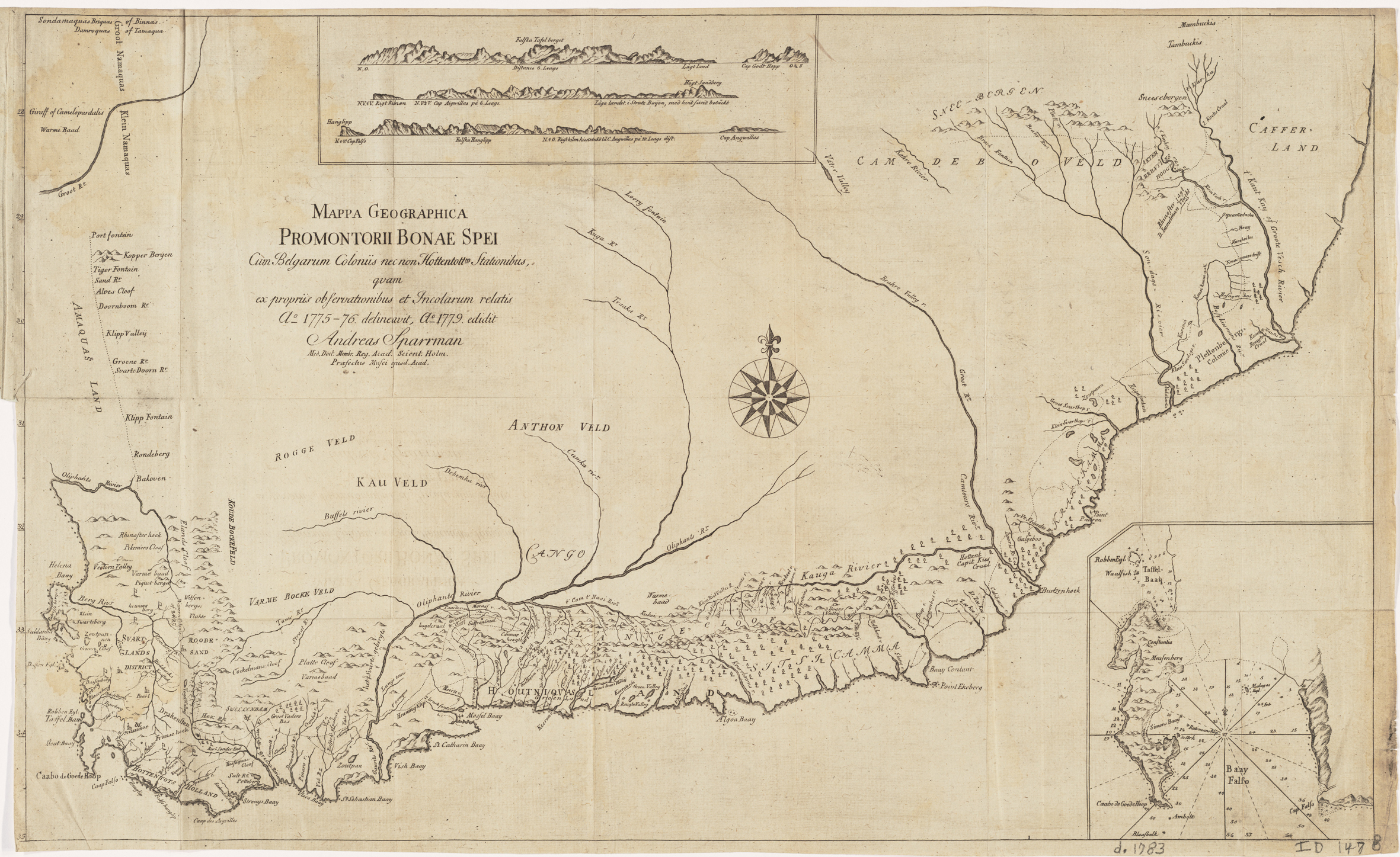
Mappa Geographica Promontorii Bonae Spei [Geographical map of the Cape of Good Hope] Cum Belgarum nec non Hottentottm Stationibus quam ex propriis observationibus et Incolarum relatis A delineavit, A 1779 edidit Andrea Sparrman Med. Coct. Membr. Reg. Acad. Scient. Holm. Praefectus Musei ejusd Acad.
First published unbound in 1779.
The illustrated map is from: Anders Sparrman, Resa Till Goda Hopps-Udden, Södra Pol-Kretsen, Och Omkring Jordklotetm Samt Till Hottentott- Och Caffer-Landen, Aren 1772-76 (Stockholm: Anders J. Nordstrom, 1783).
Sparrmann's map was the first to be published which attempted to show, in any detail, most of the area of the settlement, which extended about 800km to the east of Cape Town and 450km to the north. He made no claim of being a comptent cartographer - his primary interest was natural history; nevertheless, the map was a significant advance despite it been being 'laid down only from my own observations with a compass, and the accounts obtained from others'; the map has no longitude scale.
Sparrman had arrived in the Cape in 1772, ostensibly as a tutor. In the same year, he joined Johann Reinhold Forster, as assistant naturalist, aboard Capt. James Cook's Resolution for the circumnavigation about the Antarctic Circle. Sparrman returned to the Cape in 1775 and for two years undertook extensive journeys in the colony.
Sparrman's map was copied and the toponyms poorly translated for the travelogue of William Paterson, a plant hunter who did no mapping of the territory. François Le Vaillant's map (map #10) was based on Paterson's map and Forster's scarce Die südliche Spitze von Afrika (1796) and Charte von der südlichen Spitze von Africa (1797) were, in turn, based largely on Le Vaillant's map.
Sparrmn's coastal outline is an improvement on previous maps, although it is distorted in the north-east partly because the southern coast's inflection to the north-east occurs at Plettenberg Bay (Sparrman's Bay Contant); this is 200km too far to the west (of Algoa Bay). However, the inset of False Bay, Sparrman corrects the misshapen bay in Lacaille's map (map # 6). Sparrman introduced 244 new place names and more than half are still used today.
Sparrman's book has been considered by Cape historians as one of the most trustworthy descriptions of the colony and its people. His map is analysed in detail by Vernon Forbes (pp. 47 - 52; p.81 Paterson's map).
