William Burchell, Travels in the interior of southern Africa. (London: Longman, Hurst, Rees, Orme, Brown and Green, 1822), Volume I.
Not in Norwich or Tooley. Roger Stewart, A meticulous cartographer. William John Burchell's map of South Africa. IMCoS Journal 125 ( 2011): 12 - 15.
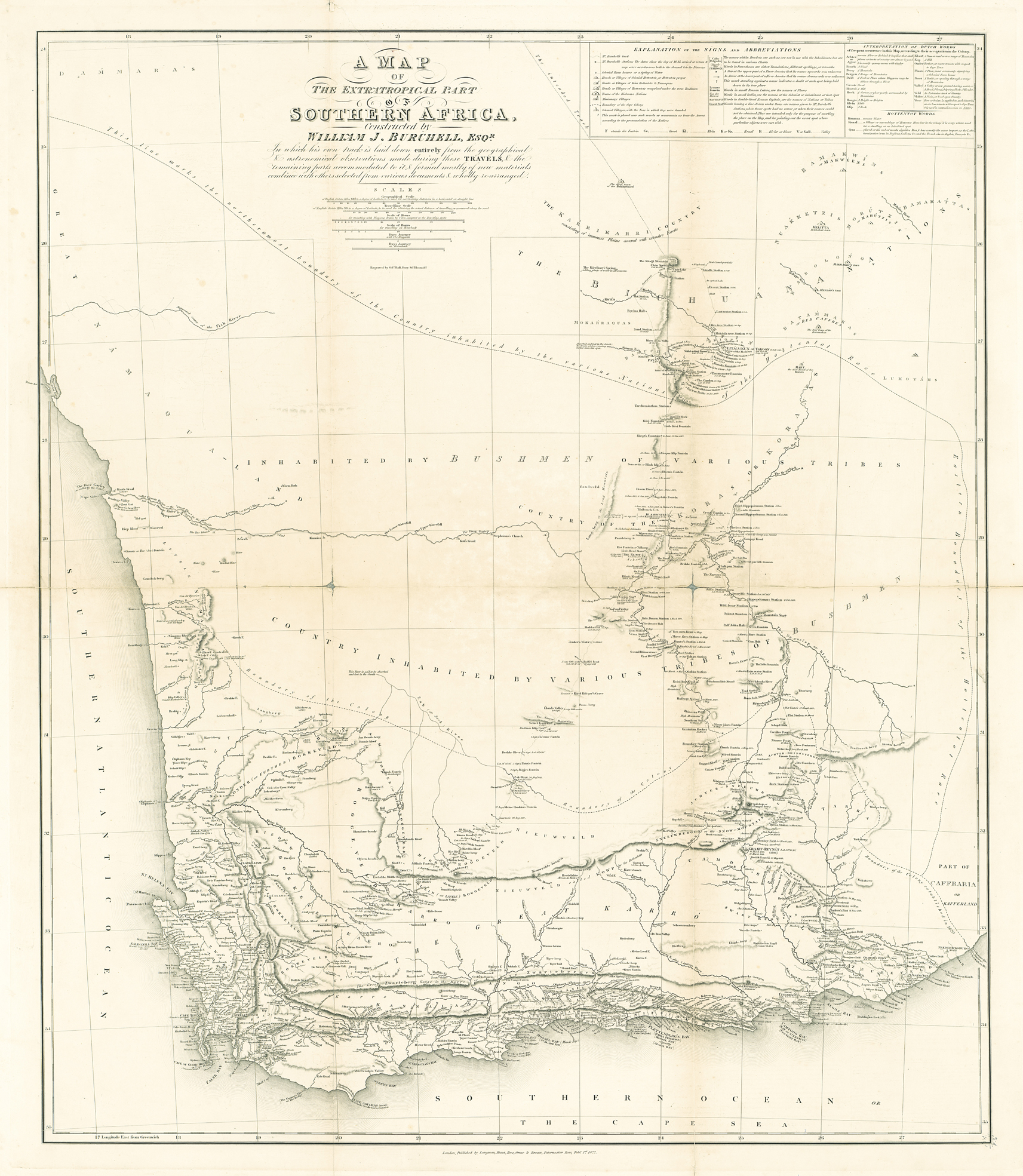
The multi-talented Burchell was a self-taught surveyor and cartographer, whose map influenced professional cartographers such as the Arrowsmiths. The map is based on Burchell's extensive travels and meticulous surveying of his route in the territory (1811 - 1815). This is the first map of the colony to be backed by a detailed description, in his book, of the author's survey and cartographic methods. For the first time, the territory beyond the north-east border of the Cape was surveyed and mapped: the land of the Cora and Tswana nations that later would be annexed by the government of the Cape Colony (Lichtenstein had travelled in the territory, taken an inaccurate latitude reading and produced a small scale map - see commentary on map #13). Burchell's map displayed his route, stations and latitudes in a level of detail that was not surpassed.
Burchell's map of Southern Africa is mentioned favourably, but usually en passant, in publications on South African cartography. Burchell devoted 5 ½ pages in Volume 1 of his book to explain his cartographic methods. His faded field sketch maps are now at Oxford University; from these and his tabulated data, Burchell constructed a map on a scale of 9 inches to one degree of latitude. The result was a large manuscript map of approximately 7 ½ feet by 8 ½ feet (2.9m x 3.3m). Burchell's map was an important primary source for the 1825 and subsequent editions of the maps of the Cape Colony by Aaron II and Samuel Arrowsmith, who plotted Burchell's route; it also was a primary source for the 1828 map of South Africa by Sydney Hall (Burchell's engraver). Furthermore, Burchell's map influenced the Hebert MS map that was used in the compilation of the landmark Arrowsmith and SDUK maps of 1834 (earlier Arrowsmith maps had been based on Barrow).
Burchell's map is rare: only 750 copies of the first volume of his book were printed and many were broken up for the illustrations and map - unbound examples of the map are scarce. His book is sought after by Africana collectors because of its veracity, its scope, beautiful prose and illustrations and its excellent map. Volume 2 is also valued for its five chapters on the anthropolgy of the Tswana nation.
