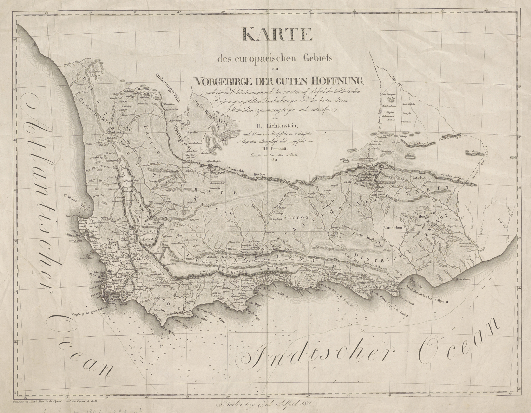
Karte des europaeischen Gebiets am Vorgebirge der Guten Hoffnung [Map of the European territory at the Cape of Good Hope]: ... entworfen von H. Lichtenstein, nach kleinerem Maassstabe (Maßstabe) in verbesserter Projection niedergelegt und ausgeführt von H. H. Gottholdt. Gestochen von Carl Mare in Berlin 1811. Gezeichnet von Joseph Jones in der Capstadt und Carl Langner in Berlin
Hinrich Lichtenstein, Reisen im südlichen Africa, in den jahren 1803, 1804, 1805 und 1806. (Berlin: C. Salfeld, 1811 & 1812).
Lichtenstein's map was an advance on Barrow's map because of the significantly more accurate longitude and because it shows the journey of both Lichtenstein, in the company of commissary-general De Mist, and the journey, a few months earlier, of the governor of the short-lived Batavian government 1803 - 1806). The map also shows the new districts of Tulbagh and Uitenhage created by the government in order to reduce the size of the Stellenbosch and Swellendam districts which had become too large to manage. As a consequence of his journey to the north-east, Lichtenstein was able to write the first creditable record of the anthropology (including the language) of the Bechuana (Tswana) nation.
Between 1803 and 1806 Henry Lichtenstein, a physician and future naturalist, visited the Cape Colony where he undertook three long journeys. Lichtenstein's map of the Cape of Good Hope has received little attention; the increased accuracy of longitude on his map was an important milestone in the history of travel and cartography in South Africa. On the other hand, Koeman (pp. 34 - 36) did not rate Lichtenstein's map as highly as others. Lichtenstein's approach to the accurate mapping of the Cape was radically different from Barrow's. The amiable Lichtenstein befriended and worked closely with and relied heavily on local surveyors, cartographers and hydrographers e.g., Josephus Jones in Cape Town.
Confusingly, Lichtenstein's map was drawn in 1811 and described in the same year in Volme 1 of his book, but published in Volume 2 (1812). New engravings of the map of the Cape of Good Hope were produced for Dutch (1814) and English (1815) translations of his book. Lichtenstein described another map in Volume 2 of his book, but it was published in elsewhere, and earlier, perhaps in draft form. All of these maps are scarce.
Lichtenstein had nothing good to say about Barrow's map (from which he did, however, draw information); when Barrow wrote a vituperative attack on Lichtentstein, he was silent on Lichtenstein's map and criticism of Barrow's map.
